Tag Archives | map

Satellite Images Show Exorbitant Levels of Air Pollution in Lebanon

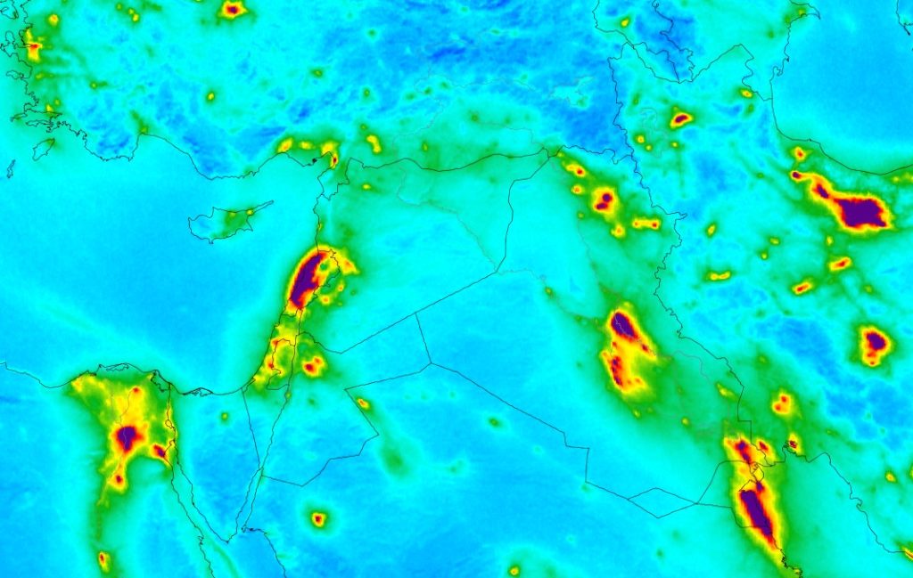
The European Space Agency (ESA) recently released several maps showing air pollution around the world after measuring the level of nitrogen dioxide over major cities using their Copernicus Sentinel-5P satellite.

This gas is an air pollutant that comes from traffic and the combustion of fossil fuel in industrial areas. And needless to say, it causes health issues by irritating the lungs and causing respiratory problems. The data was collected between April and September 2018 and the above image shows the result for part of the Middle East.

As you can see, almost all of Lebanon has very high levels of NO2 especially over the coast. And since we are by no means an industrial nation, the polluted air definitely comes from the massive number of cars and the diesel generators everywhere around the coutnry.

On the other hand, the government is as passive as ever with no plan in sight to make things better. In fact the best thing they have in mind now is to build garbage incinerators which they believe are eco-friendly. So expect the next results from the Copernicus to have Lebanon on the map replaced with a piece of shit. Literally.

0

Geography Now – Lebanon’s Episode is Out!

Geography Now is a pretty well known channel on Youtube by vlogger Paul Barbato and it discusses the world’s geography, politics, and culture one country at a time. Paul simply goes through the world countries in alphabetical order and his channel is quite popular because he delivers good information in a fun way within reasonable time (usually 10-15 minutes).

Yesterday was finally the turn for Lebanon to be the subject of his latest episode and I think he did a nice job portraying our country. He even mentioned some stuff that I’ve never heard about before such as the Striped Hyena being our national animal. (Who knew?!)

You can watch the episode below.

0

40 Art Galleries and Museums in Beirut With Their Locations

It goes without saying that Reddit has some pretty awesome content that can make even the most boring days more interesting. And for those with interest in Lebanese related stuff, there’s a fairly active subreddit (/r/Lebanon) with daily updates, vintage photos, interesting videos, and more…

One interesting contribution I came across today is a “cutural map” of Beirut by /u/EDBTZ0323 with locations for 40 prominent museums and art galleries in the city. I imagined it would be quite useful for art lovers and tourists alike and so I thought of sharing it here and you may check on this link.

2

How quickly did Lebanon adopt the internet?

lebanon

To celebrate the 25th anniversary of the world wide web, Mashable shared an interesting interactive map by Esri today showing how the web spread across the world over the past quarter-century.

The map shows that 2.7% of us the Lebanese were connected to the internet back in 1998, and the percentage has increased to 8%, 22.5%, and 61.2% in 2003, 2008, and 2012 respectively.

Make sure to check the map here and see where do we stand compared to our neighbors.

0

Powered by WordPress. Designed by WooThemes